

Bathymetry by drone:
an innovative approach to the study of the seabed
Underwater inspection, aquatic topography, lake structure control, siltation monitoring, recurring measurements, sample collection, object search… Welcome to the era of drone bathymetry, an innovative technology that is transforming the way we explore and map the seabed or lakebeds.
Forget traditional methods that are lengthy, expensive, and complex. Thanks to our drone bathymetry solutions, you can now obtain accurate and detailed data quickly, efficiently, and affordably.

What is drone bathymetry?
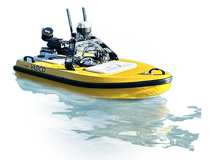
Drone bathymetry is an underwater data collection technique that uses drones equipped with specialized sensors. As pioneers in the field, we have developed our own range of aquatic and underwater drones and are also equipped with the best tools on the market. Depending on your needs, we can equip them with the necessary sensors or other functionalities…
Whether you have classic bathymetric needs, want to collect valuable information on seabed topography, water depth and other important characteristics, or are looking for tailor-made solutions, don't hesitate! We love a challenge.


The advantages of drone bathymetry
Why choose drone bathymetry for your studies and projects related to the seabed?
Some of the key advantages:
-
PRECISION AND EFFICIENCY:
Aquatic and underwater drones allow us to collect bathymetric data quickly and with high precision. The use of drone boats also enables us to carry out specific sampling or surveys to provide
-
FLEXIBILITY AND ACCESSIBILITY:
We can easily adapt our drones to different types of bodies of water, whether lakes, rivers, estuaries, or coastal areas. Deploying drones is much more economical than traditional methods.
-
SECURITY AND PROTECTION
OF THE ENVIRONMENT:
Drones allow us to conduct bathymetric surveys without endangering field teams or disturbing the marine ecosystem. This reduces risks for operators and ensures an environmentally friendly approach.
Our expertise in drone bathymetry
We are pioneers in the field of drone bathymetry, offering tailor-made solutions to meet your specific needs. With time and the technical nature of the projects we have supported, we have developed extensive experience in the use of aquatic drones and specialized sensors for collecting bathymetric data.
We work closely with you to understand your objectives, select the appropriate sensors, and carry out the necessary surveys.
Deliverables tailored
to your needs
When you choose our aquatic or underwater drone survey service, we do everything possible to provide you with high-quality deliverables that allow you to fully exploit the information collected. Whether it's accurate 3D models, detailed bathymetric maps, in-depth analysis reports, or immersive visualizations, our deliverables are designed to provide you with the information you need to make informed decisions and ensure the success of your projects.
Contact us today to learn more about our drone bathymetry solutions and discover how we can help you explore the seabed more efficiently, accurately, and accessibly than ever before.

Drone bathymetry: examples of projects


